FOR IMMEDIATE RELEASE
September 30, 2022
Contact:
Laura Lapierre, Wetlands Program Manager
Department of Environmental Conservation
802-490-6177, Laura.Lapierre@vermont.gov
Montpelier, VT – The Vermont Department of Environmental Conservation (DEC) will hold public hearings in October and November on a proposed rule to adopt edits to the state’s wetland maps.
The DEC has a map which identifies the general location of some protected wetlands (Class I and II) called the Vermont Significant Wetlands Inventory (VSWI). In 2019, the DEC completed more mapping of wetlands in the northwestern portion of Vermont in the Missisquoi River Basin. The new maps more accurately reflect wetland locations and need to be officially added to the VSWI.
“Wetlands – such as swamps, marshes, and bogs – are found throughout Vermont. They store flood water, protect clean water, and provide homes for wildlife,” said DEC Commissioner John Beling. “By updating these maps, we can help landowners avoid impacts to significant wetlands.”
From May to July 2022, the DEC received public comments on the updated VSWI. The DEC then reviewed comments and provided a responsiveness summary (bit.ly/3CK5IA0). By late August, the DEC decided to start rulemaking to formally adopt the edits to the VSWI. The Secretary of State placed the rulemaking filing on formal public notice on September 28, 2022.
Members of the public are invited to submit comments by November 12, 2022, to Laura Lapierre at Laura.Lapierre@vermont.gov and attend the upcoming public hearings:
- October 31, 2022, at 5:00 pm: Welcome Center, 51 Depot Square, Suite 100, St. Johnsbury, VT. Register to participate virtually (bit.ly/3UGJDZK).
- November 1, 2022, at 5:00 pm: Damon Hall, 1 Quechee Rd, Hartland VT. Register to participate virtually (bit.ly/3LLBgYJ).
- November 2, 2022, at 5:30 pm: RRPC Conference Room, 3rd Floor, 67 Merchants Row (Opera House), Rutland, VT. Register to participate virtually(bit.ly/3xSoK40).
- November 4, 2022, at 5:00 pm: 120 First Street, Swanton, VT. Register to participate virtually (bit.ly/3dK6H9h).
“If the State formally adopts the updated wetland maps, we can better protect these special places and their benefits,” said Beling. “However, even with the updates, we know not all protected wetlands will be mapped. You should still contact your District Wetlands Ecologist if you are proposing construction activities near a wetland, whether the wetland is mapped or not.”
Members of the public can find contact information for their District Wetlands Ecologist online (bit.ly/contactwetlands). They can also use the interactive map (bit.ly/draftwetlandmap) to view the updated VSWI.
Landowners can use the DEC’s Wetland Screening Tool (bit.ly/wetlandscreeningtool) to find out if they might have a wetland on their property. Farmers, realtors, non-profits, and towns are also encouraged to use the screening tool when making land management decisions.
Activities within protected wetlands and their 50-foot buffers often require a permit. Any unauthorized activity or construction in a significant wetland prior to its mapping is still a violation of the Wetland Rules (bit.ly/VTwetlandrules).
To learn more, view the rulemaking webpage (bit.ly/wetlandsrulemaking). If Laura Lapierre is not available, contact Julie Follensbee at Julie.Follensbee@vermont.gov or 802-490-6177.
###
The Department of Environmental Conservation is responsible for protecting Vermont’s natural resources and safeguarding human health for the benefit of this and future generations. Visit dec.vermont.gov and follow the Department of Environmental Conservation on Facebook and Instagram.
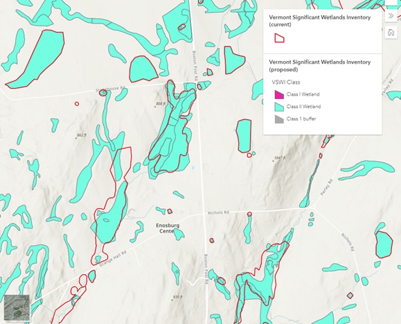
Interactive map shows the current wetland map outlined in red and the proposed map in teal.


This is nothing more than a land grab. Any one with private land in these areas will loose the ability to use their land as they choose. If they loose this land they should not have to pay any town taxes on the land.
What they don’t grab with the wetlands bull crap they prohibit building
because of the rural view…. what a bunch of commie crap..
The climate mongers claim we having droughts because of warm mongering yet their expanding the wetlands area’s???
This has severey limited the ability to build more affordable houses as zoning is restricted. Most towns in VT were built in the valleys along streams and rivers.
Sometimes I think the Powers think more of the amphibians than the people.
I agree, it happened to me last year as I have wanted to build a pond,1/2 acre of muck, for 30 years. After applying for a local permit, I was denied by the DEC. They said there might be amphibians that need protecting. What would a pond provide?
I was able to dig a “cat hole”( Mini-pond at the end of a culvert) and low and behold I have a gazillion frogs.
Ironically, it is the town that has caused the flooding of my land by dumping street run-off and refusing to clean the culverts and drainage ditches on adjacent properties. This has affected several adjoining properties as well.
My property, which I have paid taxes on for 35 years , now has a star designation as a Class 2 Wetlands. No hearing, just a bureaucrats decision.
I will file for tax grievance.